Precision Agriculture: How AI Drones are Optimizing Crop Yields in SE Asia
Precision Agriculture: Discover how AI-powered drones are transforming Southeast Asian agriculture. Learn about precision spraying, pest detection technology, and real yield improvements across the region.
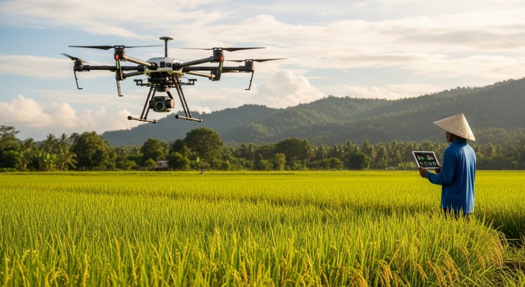
The Agricultural Revolution Taking Flight
Every year, a farmer in the Mekong Delta faces the same impossible choice: spend days manually inspecting rice paddies for pests, or risk losing an entire harvest to an infestation they never saw coming.
Every year, a durian grower in Penang walks endless rows of trees, scanning for the subtle discoloration that signals disease—knowing that by the time a problem is visible to the human eye, significant damage has already been done.
This is the reality of Southeast Asian agriculture in 2026. But it is a reality that is rapidly changing.
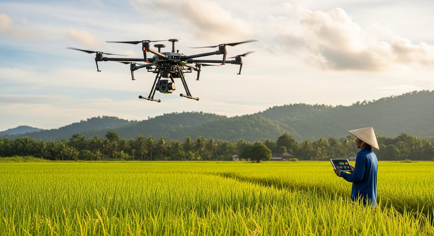
Across the region—from the rice bowls of Vietnam to the oil palm estates of Malaysia and the tea plantations of southern India—AI-powered drones are taking to the skies. They are not just replacing manual labor. They are seeing what humans cannot see, predicting what humans cannot predict, and optimizing what humans have never been able to measure .
The results are staggering: income increases of 50%, yield improvements of 54%, and water use reductions of 75% . This is not speculative futurism. This is precision agriculture, deployed at scale, across some of the world’s most challenging farming environments.
The Numbers Driving Change
The Southeast Asian drone services market was valued at USD 569.27 million in 2024. By 2033, it is projected to reach USD 6.14 billion—a compound annual growth rate of nearly 30% .
What is driving this explosive growth? Three converging forces:
1. Agriculture 4.0 Initiatives
Governments across the region are actively pushing digital transformation. Vietnam’s Mekong Delta has become the world’s most concentrated user base for agricultural spraying drones per hectare. Indonesia’s “Food Estate” projects are deploying drones for precision spraying, multispectral crop monitoring, and autonomous seeding at national scale .
2. The Smallholder Challenge
Southeast Asia’s agricultural landscape is dominated by smallholder farmers who cannot afford large machinery but desperately need efficiency gains. Drone-as-a-Service (DaaS) models—where farmers pay per hectare rather than purchasing expensive equipment—are removing adoption barriers .
3. Labor Shortages
Young people are leaving farms for cities. Manual spraying is dangerous, unhealthy, and increasingly difficult to staff. Drones solve a labor crisis that conventional solutions cannot address .
Beyond Spraying: AI-Powered Pest Detection
The most common image of agricultural drones is the sprayer—a quadcopter gliding over green fields, misting crops from above. But this is only the surface.
The real revolution is happening in the computer vision systems that give these drones their intelligence.
The EN-YOLO Breakthrough for Durian Orchards
Durian—Southeast Asia’s “king of fruits”—is notoriously difficult to farm. The orchards are dense. The lighting changes dramatically throughout the day. And the pests and diseases that threaten yields often blend perfectly with leaves and fruit .
Manual inspection is virtually impossible at scale. Farmers lack professional knowledge. The experts who have it are too few to cover large areas. Wrong identifications lead to widespread pest spread and catastrophic yield declines .
Enter EN-YOLO—a novel deep learning model specifically designed for durian pest and disease detection.
How it works:
EN-YOLO combines three key innovations:
- EfficientNet Backbone: A neural network architecture optimized for small object detection, enabling the model to spot tiny insects or early-stage lesions that human eyes miss
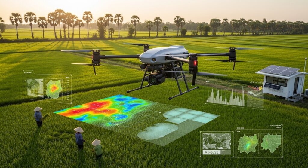
- Multimodal Fusion: The system processes not just standard RGB images but also near-infrared and thermal imaging—allowing it to see through foliage and detect problems in low light or under canopy cover
- Cross-Scene Generalization: Unlike previous models that failed when moved from one orchard to another, EN-YOLO maintains accuracy across different farms, weather conditions, and growth stages
The results from real Malaysian orchards:
- 95.3% counting accuracy for pest and disease identification
- Superior performance compared to YOLOv8, YOLOv5-EB, and Fieldsentinel-YOLO
- Effective detection across four major threat types: Leaf blight, Algae spot disease, Red spider mites, and Psyllid
The dataset behind this achievement is substantial: over 17,000 images collected from a durian base in Penang, Malaysia, covering seedling, flowering, and fruiting stages across six different environmental conditions—from strong noon sunlight to infrared imaging at night .
Tea Mosquito Bug Surveillance in Kerala
Halfway across the region, in the tea plantations of southern India, a similar revolution is underway.
The tea mosquito bug (TMB) has been stalking Kerala’s plantations since 1922. It remains one of the most devastating threats to tea yields—and one of the hardest to detect early .
In October 2025, a partnership between C-DAC Kolkata, IIT Kharagpur, and the UPASI Tea Research Foundation launched an AI-driven aerial imaging solution specifically for TMB detection .
The system, called PEST Track, includes:
- Drone-based aerial surveillance using RGB cameras under optimized flight conditions
- Deep learning object detection models trained specifically to identify TMB infestations from canopy-level imagery
- A mobile application that uses georeferenced data to guide field personnel to exact infestation locations
- Ti Mapper, a web-based decision support tool from IIT Kharagpur that generates infestation contour maps and pinpoints affected zones for targeted pesticide application
The impact is immediate: Instead of blanket-spraying entire plantations (wasting chemicals and harming beneficial insects), workers can walk directly to the affected GPS coordinates identified by the AI and apply treatment only where needed .
The Next Frontier: Map-Free, AI-Vision Spraying
The current generation of agricultural drones still has a significant limitation: most require manual pre-mapping before each deployment. An operator must survey the field, generate a static flight plan, and repeat the entire process whenever terrain or planting patterns change .
In oil palm plantations—where trees are planted on uneven terrain, at varying ages, across thousands of hectares—this mapping overhead severely limits how many acres a team can cover.
GEODASH Aerosystems, a joint venture between DroneDash Technologies and GEODNET (the world’s largest decentralized GNSS-RTK network), is solving this problem .
Their new drone platform, targeted for commercial deployment in Q3 2026, eliminates pre-mapping entirely:
- Real-time AI Vision perceives plantation structure, canopy height, and terrain features during flight
- Centimetre-accurate RTK positioning (from GEODNET’s satellite correction network) provides precise location data throughout each mission
- Dynamic interpretation of rows, trees, and operational zones means the drone adapts to what it sees, not what a map predicted
The capabilities are unprecedented:
- Deployment without any pre-survey or manual mission planning
- Continuous altitude and spray-rate adjustment over variable terrain
- Rapid redeployment after replanting or field reconfiguration
- Tree-level and zone-specific variable-rate application
Beyond spraying, each GEODASH drone functions as a continuous aerial intelligence layer. Spraying missions generate field data used for canopy density analysis, crop stress detection, zone-level health scoring, and historical trend analysis across seasons .
Real-World Impact: The Aonic Story
While new technologies emerge, proven deployments are already delivering measurable results at scale.
Aonic, a Malaysia-founded drone technology company, has built an end-to-end ecosystem that spans drone design, manufacturing, software development, training, financing, and after-sales support .
The scale of their operation:
- Over 50 3S (Sales, Service, Spare Parts) centers across Southeast Asia
- Market leadership in both Malaysia and Thailand for agri-drones
- Drones deployed in over 15 countries
- Profitable since 2023, with triple-digit CAGR since 2022 and annual revenue exceeding USD 60 million
The impact on farmers:
Based on internal performance data across participating farms, Aonic’s agriculture drones have demonstrated:
- 50% increase in farmers’ income
- 54% boost in farm output
- 75% reduction in water use for spraying compared to manual methods
This is not incremental improvement. This is transformation.
In March 2026, Aonic secured an additional USD 10 million in Series A funding, led by Kairous Capital and backed by Malaysia’s National Fund-of-Funds. The investment will accelerate R&D and scale manufacturing capacity for the next phase of growth .
The Enabling Environment: Government and Policy Support
Technology alone cannot drive adoption. Southeast Asian governments are actively creating the conditions for precision agriculture to flourish.
Malaysia: World Bank-Backed Digital Transformation
A World Bank report released in October 2024 concluded that widespread adoption of digital agriculture technologies (DATs)—including GPS, drones, and sensors—will accelerate Malaysia’s journey to high-income nation status .
The report, “Farming the Future: Harvesting Malaysia’s Agricultural Resilience through Digital Technologies,” identifies three priority areas:
- Increased financing for public goods to provide resources for DAT implementation
- Greater investment in the innovation ecosystem to foster development
- Creation of an enabling environment through clear strategies for data governance, privacy, security, and incentive frameworks
The agriculture sector rebounded with 7.2% growth in Q2 2024, and the World Bank projects overall Malaysian economic growth of 4.9% for 2024—with digital agriculture playing a key role .
Vietnam: The Mekong Delta as Global Model
Vietnam’s Mekong Delta has become the world’s most concentrated user base for agricultural spraying drones per hectare. The country’s “Agriculture 4.0” initiatives have created a regulatory environment that encourages rather than hinders adoption .
Thailand: Integration with Economic Corridors
Thailand has successfully integrated drones into its “Eastern Economic Corridor” (EEC) for industrial monitoring, with over 13,000 registered drones and projections exceeding 100,000 within a decade .
Localization: The Key to Success
Global drone platforms cannot simply be dropped into Southeast Asian farms and expected to perform. Localization is essential—and it goes far beyond translating user interfaces.
Tropicalization: Southeast Asia’s humid, monsoon-prone environment destroys standard electronics. Successful providers engineer drones with high-grade waterproofing and heat resistance specifically for these conditions .
Crop-Specific Algorithms: A model trained on wheat fields in Kansas will fail on durian orchards in Penang. The EN-YOLO project succeeded precisely because it was trained on real data from Malaysian farms, collected across the full range of local growing conditions .
Financing Models: Smallholder farmers cannot afford $10,000 drones. Aonic’s “Flex” financing program and Drone Academy Asia’s certified training lower upfront barriers and enable adoption at scale .
Service Networks: When a drone breaks during peak spraying season, downtime is measured in lost yields. Aonic’s network of 50+ service centers ensures responsive, on-the-ground support long after deployment .
Challenges and the Path Forward
Despite the remarkable progress, significant challenges remain.
Data scarcity: Training robust AI models requires massive, high-quality annotated datasets. The EN-YOLO team collected over 17,000 images—but even that is modest compared to what is available for high-resource crops in developed countries .
Regulatory fragmentation: Drone regulations vary significantly across Southeast Asian countries. Companies must navigate different permitting processes, altitude restrictions, and operational rules in each market .
Connectivity limitations: Real-time AI processing and RTK positioning require reliable internet connectivity—still not universal across rural Southeast Asia. Edge processing capabilities (AI running directly on the drone) are essential for many regions .
Adoption barriers for smallholders: The World Bank report explicitly notes that historically low adoption of new technologies is a key challenge. Beyond financing, farmers need training, proven ROI demonstrations, and trust in new systems .
What This Means for You
For farmers and plantation managers: The technology is proven and available. Start with a pilot on a portion of your land. Measure the results. The ROI—50% income increases, 54% yield improvements—speaks for itself .
For agribusiness investors: The Southeast Asian drone market is growing at nearly 30% CAGR . Companies with local manufacturing, service networks, and proven results (like Aonic) represent significant opportunities.
For policymakers: The World Bank framework provides a clear roadmap: financing for public goods, investment in innovation ecosystems, and enabling environments for data governance . Act on it.
For technology providers: Localization is not optional. Build for tropical conditions. Train on local data. Offer financing. Train users. Support deployments long-term.
The Future: Autonomous Intelligence
The trajectory is clear. Today’s drones require human operators for most decisions. Tomorrow’s will not.
The GEODASH platform’s map-free, AI-vision approach is a preview of fully autonomous agriculture—where drones not only spray but continuously monitor, analyze, and recommend actions without human intervention .
The backend AI analytics will become increasingly sophisticated, delivering:
- Early indicators of pest, disease, or nutrient stress before visible symptoms appear
- Identification of underperforming zones for targeted intervention
- Optimized spray timing and dosage based on real-time conditions
- Data-informed planning for replanting and fertilization
The drone becomes not a spraying machine but a continuous aerial intelligence layer—the eyes and brain of the farm, operating 24/7.
Frequently Asked Questions
Q: How much do agricultural drones cost in Southeast Asia?
A: Costs vary, but DaaS (Drone-as-a-Service) models allow farmers to pay per hectare rather than purchasing equipment. Aonic offers “Flex” financing to lower upfront barriers .
Q: Can drones work in rainy or cloudy conditions?
A: Modern systems incorporate thermal and near-infrared imaging that perform in low light and partial cloud cover. However, heavy rain remains challenging. The EN-YOLO system specifically includes infrared imaging for night operations .
Q: Do I need to be a tech expert to operate these drones?
A: No. Providers like Aonic include certified training through Drone Academy Asia. The systems are designed for farmers, not engineers .
Q: What crops can benefit from AI drone technology?
A: Current deployments cover rice (Vietnam), durian (Malaysia), tea (India), oil palm (throughout SE Asia), sugarcane, and broad-acre row crops. The underlying technology is adaptable to any crop with sufficient training data .
Q: How accurate is AI pest detection compared to human experts?
A: EN-YOLO achieves 95.3% counting accuracy in durian orchards—matching or exceeding human experts while operating at vastly greater scale and speed .